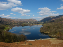
Ordnance Survey Name Books for Cumberland and Westmorland
The Name Books help us to imagine life and landscape in the mid 19th century — a time of rapid and radical change. "
Diana Whaley, Professor Emeritus of Early Medieval Studies, Newcastle University
Ordnance Survey Name Books for Cumberland and Westmorland
The present collection, which comprises the Original Name Books for the Parish of Grasmere, has been produced as part of 'Envisaging Landscapes and Naming Places: the Lake District before the Map', a project funded by the British Academy/Leverhulme Trust Small Research Grants Scheme.
How did the names we find on Ordnance Survey maps get there? Who was it who chose those names? What do those names reveal about the history of the places they describe? What, by the same token, do those names conceal? This collection helps answer all these questions and more.
The collection comprises the first instalment of the digitised Ordnance Survey Original Name Books for Cumberland and Westmorland. These books date to the 1850s and 1860s, and they provide an exceptional documentary record of the processes by which regional identity was redefined by cartography during the later Victorian era.
The Name Books are, in essence, the records of the fieldwork that was done to determine the names and spellings that were used in the OS’s 1st edition, 6” maps of the historic counties of Cumberland and Westmorland. The books themselves, which are now held in The National Archives, were created by Royal Engineer surveyors and civilian assistants who, in addition to their surveying work, collected information about the places they were surveying from local informants.
The Name Books were crucial to this process. They provided the table that the surveyors and their assistants used to record and organise their findings. Consequently, the Name Books reveal a great deal about the Ordnance Survey’s methods, and they give us unique glimpses into how the landscape of different parts of Britain and Ireland looked and were perceived more than 170 years ago.
The Name Books are also an important source of information about the place-names themselves, many of which were formed more than a millennium prior to their collection by the Ordnance Survey. Studying the Name Books therefore provides a unique insight into the landscape in two periods of history: the Middle Ages and the Victorian era.
As Diana Whaley has put it, the Name Books allow 'us to imagine life and landscape in the mid-nineteenth century', shedding new light on places that still exist and sometimes revealing much about places that have not survived.
The Ordnance Survey Name Books for Cumberland and Westmorland are also extremely rare. Almost all the Name Books for England & Wales were destroyed during a bombing raid on Southampton in 1940. Only the books for Cumberland, Westmorland, Northumberland and Durham have survived, along with the books for part of Hampshire.
Previous projects, including a project led by Diana Whaley for Northumberland, have completed the digitisation of some of the surviving Name Books. But the Names Books for Cumberland and Westmorland have not yet been digitised. What is more, they have never been studied in detail before. The 'Envisaging Landscapes and Naming Places' project is a pilot study of the two Name Books for Grasmere parish. We hope to expand this collection to cover the rest of Cumberland and Westmorland in the future.
Further reading
- Rachel Hewitt, Map of a Nation: A Biography of the Ordnance Survey (London: Granta, )
- Diana Whaley, et al., Northumberland Name Books () [accessed ]
- Diana Whaley, Putting Northumberland names on the map: insights from the Ordnance Survey Name Books c. 1860, Nomina, 40 (–), 1–28.
- E. Williamson, The Ordnance Survey name books: a "treasure-trove" for toponymists, Scottish Archives, 25/26 (), 42–55.
- Scotland’s Places
Acknowledgements
© Images reproduced by permission of The National Archives, London, England.
The National Archives give no warranty as to the accuracy, completeness or fitness for the purpose of the information provided.
Images may be used only for purposes of research, private study or education.
Applications for any other use should be made to The National Archives Image Library, Kew, Richmond, Surrey TW9 4DU, Tel: 020 8392 5225 Fax: 020 8392 5266.
We would like to thank the following volunteer transcribers:
David Allen, Haydn Charlesworth, Lynne Farquharson and Richard
Hardisty.
The project team is:
Dr James Butler, Dr Chris Donaldson, Professor Fiona Edmonds and
Professor Ian Gregory.
The research underpinning this project was funded by the British Academy/Leverhulme Trust Small Research Grants Scheme (award SRG2021\210552).